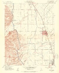
1952 Map of Newman
USGS Topo · Published 1954About this map
The agricultural corridor of the San Joaquin Valley is defined by the Southern Pacific railroad and the San Joachim Canal in this mid-century look at the border of Stanislaus and Merced Counties. The settlement of Newman serves as a central hub, flanked by the smaller rail stops of Stomar and Timba to the north and Gustine to the south. The transition from the flat irrigated valley floor to the rising hills is marked by the Orestimba Creek drainage and the Poverty Flat terrain, where the Stimba Pumping Station and various siphons manage the critical movement of water.
Find a feature on this map
45 named features on this map. Tap any name to fly to it.
Don’t see what you’re looking for? This feature index may not catch every label — zoom into the map to look around manually.
Map Details
Editions of this 1952 Newman Map
4 editions found
Other maps of this area

1916 · Mitchell School
USGS Topo · 1:31,680

1916 · Crows Landing
USGS Topo · 1:31,680

1916 · Patterson
USGS Topo · 1:31,680

1917 · Newman
USGS Topo · 1:31,680

1918 · Gustine
USGS Topo · 1:31,680

1919 · Orestimba
USGS Topo · 1:62,500

1919 · Orestimba Creek
USGS Topo · 1:31,680

1919 · Ingomar
USGS Topo · 1:31,680

1920 · Pacheco Pass
USGS Topo · 1:62,500

1922 · Howard Ranch
USGS Topo · 1:31,680