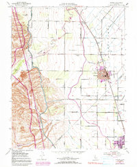
1952 Map of Newman
USGS Topo · Published 1991About this map
Agricultural development and water management define this Central Valley landscape, centered on the growing community of Newman. The 1952 culture and 1971 urban revisions highlight the expansion of the town and its neighbor, Gustine, as they sit along the border of Stanislaus and Merced counties. A massive engineering footprint is visible in the Delta-Mendota Canal and the Main Canal, which weave through the terrain alongside the Newman Waste-Way.
Find a feature on this map
50 named features on this map. Tap any name to fly to it.
Don’t see what you’re looking for? This feature index may not catch every label — zoom into the map to look around manually.
Map Details
Editions of this 1952 Newman Map
4 editions found
Other maps of this area

1916 · Mitchell School
USGS Topo · 1:31,680

1916 · Crows Landing
USGS Topo · 1:31,680

1916 · Patterson
USGS Topo · 1:31,680

1917 · Newman
USGS Topo · 1:31,680

1918 · Gustine
USGS Topo · 1:31,680

1919 · Orestimba
USGS Topo · 1:62,500

1919 · Orestimba Creek
USGS Topo · 1:31,680

1919 · Ingomar
USGS Topo · 1:31,680

1920 · Pacheco Pass
USGS Topo · 1:62,500

1922 · Howard Ranch
USGS Topo · 1:31,680