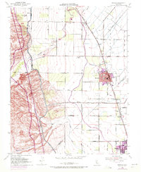
1952 Map of Newman
USGS Topo · Published 1972About this map
The agricultural landscape of the San Joaquin Valley is defined here by an intricate network of irrigation and rail infrastructure, centered on the growing community of Newman. The Southern Pacific railroad corridor serves as the primary spine for the region, connecting the smaller sidings of Stomar and Timba to the larger hubs. Significant water management features, including the Delta-Mendota Canal and the Newman Waste-Way, illustrate the mid-century engineering required to sustain this fertile corridor.
Find a feature on this map
42 named features on this map. Tap any name to fly to it.
Don’t see what you’re looking for? This feature index may not catch every label — zoom into the map to look around manually.
Map Details
Editions of this 1952 Newman Map
4 editions found
Other maps of this area

1916 · Mitchell School
USGS Topo · 1:31,680

1916 · Crows Landing
USGS Topo · 1:31,680

1916 · Patterson
USGS Topo · 1:31,680

1917 · Newman
USGS Topo · 1:31,680

1918 · Gustine
USGS Topo · 1:31,680

1919 · Orestimba
USGS Topo · 1:62,500

1919 · Orestimba Creek
USGS Topo · 1:31,680

1919 · Ingomar
USGS Topo · 1:31,680

1920 · Pacheco Pass
USGS Topo · 1:62,500

1922 · Howard Ranch
USGS Topo · 1:31,680