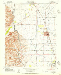
1952 Map of Newman
USGS Topo · Published 1954About this map
Newman and Gustine anchor this mid-century survey of the California Central Valley, where the Southern Pacific railroad parallels a complex network of irrigation infrastructure. The landscape is defined by its transition from the steep terrain of Poverty Flat and Bennett Valley in the west down to the managed agricultural floor. Extensive engineering is evident in the Delta-Mendota Canal and the Main Canal, which cut across the historical Orestimba Grant Boundary. Local industry and services are well-documented, including the Stimba Pumping Station, several Gravel Pits, and the West Side Hosp. Small rural stops like Stomar and Timba appear along the rail line, while the San Joachim Cem and the High Sch in Newman provide key reference points for genealogists and local historians studying this era of San Joaquin Valley development.
Find a feature on this map
51 named features on this map. Tap any name to fly to it.
Don’t see what you’re looking for? This feature index may not catch every label — zoom into the map to look around manually.
Map Details
Editions of this 1952 Newman Map
4 editions found
Other maps of this area

1916 · Mitchell School
USGS Topo · 1:31,680

1916 · Crows Landing
USGS Topo · 1:31,680

1916 · Patterson
USGS Topo · 1:31,680

1917 · Newman
USGS Topo · 1:31,680

1918 · Gustine
USGS Topo · 1:31,680

1919 · Orestimba
USGS Topo · 1:62,500

1919 · Orestimba Creek
USGS Topo · 1:31,680

1919 · Ingomar
USGS Topo · 1:31,680

1920 · Pacheco Pass
USGS Topo · 1:62,500

1922 · Howard Ranch
USGS Topo · 1:31,680