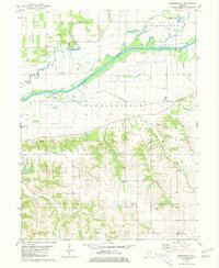
1981 Map of Newmansville
USGS Topo · Published 1981About this map
The Sangamon River meanders across this central Illinois landscape, forming the natural border between Mason County and Cass County. This transition from the river bottomlands to the elevated bluffs is marked by a complex network of wetlands and seasonal water bodies, including Anderson Slough, Long Slough, and Fish Lake. The area's settlement history is preserved in small communities like Newmansville and White City, and a high concentration of rural burial grounds. Genealogists will find several family and community landmarks such as Whitty Cem, Harbison Cem, and the Little Shepherd Cem. To the south, the terrain rises into the distinctive Shick Shack Hill before leveling out toward the Panther Creek drainage, illustrating the agricultural and topographical divide typical of this river valley region.
Find a feature on this map
34 named features on this map. Tap any name to fly to it.
Don’t see what you’re looking for? This feature index may not catch every label — zoom into the map to look around manually.
Map Details
Editions of this 1981 Newmansville Map
This is the sole edition of this map. No revisions or reprints were ever made.
Other maps of this area

1909 · Tallula
USGS Topo · 1:62,500

1930 · Chandlerville
USGS Topo · 1:62,500

1932 · Chandlerville
USGS Topo · 1:62,500

1932 · Virginia
USGS Topo · 1:62,500

1933 · Petersburg
USGS Topo · 1:62,500

1936 · Virginia
USGS Topo · 1:62,500

1938 · Petersburg
USGS Topo · 1:62,500

1940 · Tallula
USGS Topo · 1:62,500

1948 · Quincy
USGS Topo · 1:250,000

1956 · Quincy
USGS Topo · 1:250,000