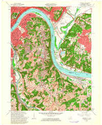
1961 Map of Newport
USGS Topo · Published 1963About this map
The Ohio River and Licking River define this mid-century landscape where Kentucky and Ohio meet. Major urban centers like Newport, Covington, and Bellevue are densely developed, showing the expansion of residential neighborhoods into the hills of Fort Thomas and Highland Heights. The map highlights a significant concentration of religious and social institutions, including St Annes Convent, St Josephs Orphanage, and Our Lady of Cincinnati College.
Find a feature on this map
105 named features on this map. Tap any name to fly to it.
Don’t see what you’re looking for? This feature index may not catch every label — zoom into the map to look around manually.
Map Details
Editions of this 1961 Newport Map
3 editions found
Other maps of this area

1898 · East Cincinnati
USGS Topo · 1:62,500

1914 · East Cincinnati
USGS Topo · 1:62,500

1914 · West Cincinnati
USGS Topo · 1:62,500

1929 · Alexandria
USGS Topo · 1:48,000

1936 · Alexandria
USGS Topo · 1:62,500

1950 · Independence
USGS Topo · 1:24,000

1950 · Covington
USGS Topo · 1:24,000

1952 · Newport
USGS Topo · 1:24,000

1953 · Withamsville
USGS Topo · 1:24,000

1953 · New Richmond
USGS Topo · 1:24,000