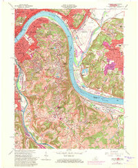
1961 Map of Newport
USGS Topo · Published 1971About this map
The Ohio River snakes through this 1961 survey, serving as the vital corridor between Cincinnati, Ohio, and the northern Kentucky river cities. On the Kentucky side, dense residential patterns define Newport, Bellevue, and Dayton, while the higher ground to the south supports expansive sites like Evergreen Cemetery and the VA Hospital near Fort Thomas. Infrastructure of the era is prominent, from the Cincinnati Municipal Airport (Lunken Field) in the Little Miami River bottomlands to the Chesapeake And Ohio and Louisville And Nashville rail lines that follow the riverbanks.
Find a feature on this map
111 named features on this map. Tap any name to fly to it.
Don’t see what you’re looking for? This feature index may not catch every label — zoom into the map to look around manually.
Map Details
Editions of this 1961 Newport Map
3 editions found
Other maps of this area

1898 · East Cincinnati
USGS Topo · 1:62,500

1914 · East Cincinnati
USGS Topo · 1:62,500

1914 · West Cincinnati
USGS Topo · 1:62,500

1929 · Alexandria
USGS Topo · 1:48,000

1936 · Alexandria
USGS Topo · 1:62,500

1950 · Independence
USGS Topo · 1:24,000

1950 · Covington
USGS Topo · 1:24,000

1952 · Newport
USGS Topo · 1:24,000

1953 · Withamsville
USGS Topo · 1:24,000

1953 · New Richmond
USGS Topo · 1:24,000