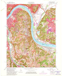
1961 Map of Newport
USGS Topo · Published 1975About this map
The Ohio River and Licking River define the industrial and residential landscape of Northern Kentucky and Southern Ohio in this mid-century survey. Urban density is highest in Newport, Covington, and Dayton, where complex rail networks like the Louisville and Nashville RR and Chesapeake and Ohio RR facilitate cross-river commerce. The map documents significant local landmarks including the sprawling Evergreen Cemetery and the leisure hub of Coney Island Amusement Park alongside the River Downs Racetrack.
Find a feature on this map
90 named features on this map. Tap any name to fly to it.
Don’t see what you’re looking for? This feature index may not catch every label — zoom into the map to look around manually.
Map Details
Editions of this 1961 Newport Map
3 editions found
Other maps of this area

1898 · East Cincinnati
USGS Topo · 1:62,500

1914 · East Cincinnati
USGS Topo · 1:62,500

1914 · West Cincinnati
USGS Topo · 1:62,500

1929 · Alexandria
USGS Topo · 1:48,000

1936 · Alexandria
USGS Topo · 1:62,500

1950 · Independence
USGS Topo · 1:24,000

1950 · Covington
USGS Topo · 1:24,000

1952 · Newport
USGS Topo · 1:24,000

1953 · Withamsville
USGS Topo · 1:24,000

1953 · New Richmond
USGS Topo · 1:24,000