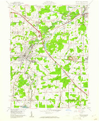
1959 Map of Newton Falls
USGS Topo · Published 1961About this map
The Mahoning River carves a winding path through this industrial and agricultural landscape of eastern Ohio, where the steel-era influence is visible at the massive Slag Pile near the Lordstown Mil Res. Newton Falls serves as the central hub, defined by the convergence of the West Branch and the main river channel. Heavy infrastructure dominates the region, with the Ohio Turnpike slicing diagonally across the terrain, intersecting a dense network of rail lines including the Erie-Lackawanna and Baltimore and Ohio. To the west, the U S Military Reservation Ravenna Arsenal occupies a significant portion of the map, while local history is preserved in scattered sites like St Michaels Cem and Duck Creek Cem. The southern edge captures the burgeoning recreation area near Craig Beach at Lake Milton, providing a sharp contrast to the rail-side settlements of Phalanx Station and Braceville.
Find a feature on this map
38 named features on this map. Tap any name to fly to it.
Don’t see what you’re looking for? This feature index may not catch every label — zoom into the map to look around manually.
Map Details
Editions of this 1959 Newton Falls Map
4 editions found
Other maps of this area

1905 · Bristolville
USGS Topo · 1:62,500

1905 · Garrettsville
USGS Topo · 1:62,500

1906 · Ravenna
USGS Topo · 1:62,500

1907 · Bristolville
USGS Topo · 1:62,500

1907 · Garrettsville
USGS Topo · 1:62,500

1908 · Warren
USGS Topo · 1:62,500

1908 · Ravenna
USGS Topo · 1:62,500

1950 · Cleveland
USGS Topo · 1:250,000

1952 · Lake Milton
USGS Topo · 1:24,000

1952 · Canfield
USGS Topo · 1:24,000