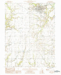
1985 Map of Newton
USGS Topo · Published 1985About this map
The Embarras River flows across the northern reaches of this Jasper County landscape, anchoring the regional hub of Newton. This 1985 survey illustrates the transition from the structured street grid of the county seat to the sprawling agricultural tracts of Wade and Smallwood townships. A significant portion of the western terrain is dedicated to the Jasper County State Prairie Chicken Sanctuary, reflecting localized efforts to preserve the native grassland habitat amidst intensive farming.
Find a feature on this map
29 named features on this map. Tap any name to fly to it.
Don’t see what you’re looking for? This feature index may not catch every label — zoom into the map to look around manually.
Map Details
Editions of this 1985 Newton Map
This is the sole edition of this map. No revisions or reprints were ever made.
Other maps of this area

1940 · Greenup
USGS Topo · 1:62,500

1941 · Newton
USGS Topo · 1:62,500

1943 · Greenup
USGS Topo · 1:62,500

1943 · Newton
USGS Topo · 1:62,500

1953 · Teutopolis
USGS Topo · 1:62,500

1953 · Sailor Springs
USGS Topo · 1:62,500

1958 · Decatur
USGS Topo · 1:250,000

1958 · Belleville
USGS Topo · 1:250,000

1961 · Decatur
USGS Topo · 1:250,000

1962 · Belleville
USGS Topo · 1:250,000