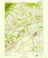
1952 Map of Newville
USGS Topo · Published 1958About this map
Newville serves as the central hub of this mid-century survey, situated at the confluence of the Pennsylvania railroad line and the winding Conodoguinet Creek. The landscape transition is stark, moving from the forested heights of Blue Mountain in the north through the agricultural valleys of Lower Mifflin and Newton townships. The map documents a dense network of local education and faith, featuring numerous rural schoolhouses like the Gillespie School and Oak Flat School, alongside established congregations at Bethany Church and Zion Church.
Find a feature on this map
48 named features on this map. Tap any name to fly to it.
Don’t see what you’re looking for? This feature index may not catch every label — zoom into the map to look around manually.
Map Details
Editions of this 1952 Newville Map
3 editions found
Other maps of this area

1919 · Newville
USGS Topo · 1:62,500

1919 · Mattawana
USGS Topo · 1:62,500

1923 · Shippensburg
USGS Topo · 1:62,500

1930 · Loysville
USGS Topo · 1:62,500

1933 · Loysville
USGS Topo · 1:62,500

1936 · East Waterford
USGS Topo · 1:48,000

1941 · East Waterford
USGS Topo · 1:62,500

1943 · Shippensburg
USGS Topo · 1:62,500

1945 · Newville
USGS Topo · 1:62,500

1945 · Shippensburg
USGS Topo · 1:62,500
Featured Places
- North Newton Township, PA
- West Pennsboro Township, PA
- Newville, PA
- Oakville, North Newton Township
- Upper Frankford Township, PA