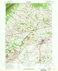
1952 Map of Newville
USGS Topo · Published 1970About this map
Conodoguinet Creek carves a winding path across the Cumberland Valley, framing a landscape defined by traditional Pennsylvania farming townships and mid-century infrastructure. The borough of Newville stands as a central hub, where the Penn Central railroad and the Pennsylvania Turnpike intersect a region deeply rooted in communal life. The map reveals a dense network of local landmarks, including the John Graham Memorial Cemetery and various country schoolhouses such as the Oak Flat School and Gillespie School.
Find a feature on this map
46 named features on this map. Tap any name to fly to it.
Don’t see what you’re looking for? This feature index may not catch every label — zoom into the map to look around manually.
Map Details
Editions of this 1952 Newville Map
3 editions found
Other maps of this area

1919 · Newville
USGS Topo · 1:62,500

1919 · Mattawana
USGS Topo · 1:62,500

1923 · Shippensburg
USGS Topo · 1:62,500

1930 · Loysville
USGS Topo · 1:62,500

1933 · Loysville
USGS Topo · 1:62,500

1936 · East Waterford
USGS Topo · 1:48,000

1941 · East Waterford
USGS Topo · 1:62,500

1943 · Shippensburg
USGS Topo · 1:62,500

1945 · Newville
USGS Topo · 1:62,500

1945 · Shippensburg
USGS Topo · 1:62,500
Featured Places
- North Newton Township, PA
- West Pennsboro Township, PA
- Newville, PA
- Oakville, North Newton Township
- Upper Frankford Township, PA