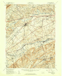
1952 Map of Newville
USGS Topo · Published 1959About this map
Conodoguinet Creek and Yellow Breeches Creek define the agricultural and wooded landscape of Cumberland County during the early 1950s. The borough of Newville serves as a central hub, surrounded by a dense network of rural one-room schoolhouses like Green Hill Sch and Whisky Run Sch, many of which were already becoming relics of a passing era of education. To the south, the terrain rises sharply into the mountains of Pine Grove Furnace State Park, where the Appalachian Trail winds past Fuller Lake and the site of Camp Michaux.
Find a feature on this map
115 named features on this map. Tap any name to fly to it.
Don’t see what you’re looking for? This feature index may not catch every label — zoom into the map to look around manually.
Map Details
Editions of this 1952 Newville Map
3 editions found
Other maps of this area

1902 · Chambersburg
USGS Topo · 1:62,500

1904 · Carlisle
USGS Topo · 1:62,500

1907 · New Bloomfield
USGS Topo · 1:62,500

1908 · Gettysburg
USGS Topo · 1:62,500

1909 · Fairfield
USGS Topo · 1:62,500

1919 · Newville
USGS Topo · 1:62,500

1919 · Mattawana
USGS Topo · 1:62,500

1923 · Shippensburg
USGS Topo · 1:62,500

1930 · Loysville
USGS Topo · 1:62,500

1933 · Loysville
USGS Topo · 1:62,500
Featured Places
- Shippensburg, PA
- Dickinson, Penn Township
- Plainfield, West Pennsboro Township
- Southampton Township, PA
- North Newton Township, PA