
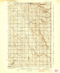
1939 Map of Niagara
USGS Topo · Published 1939About this map
Adler Moraine dominates the central topography of this Grand Forks and Nelson County region, marking the glacial legacy of the North Dakota landscape. The Great Northern railroad cuts through the northern edge, anchoring the town of Niagara, while the surrounding prairie is meticulously organized by a grid of rural school districts and community landmarks. Researchers will find numerous localized institutions such as the Christianson Sch, Henningson Sch, and Linn Ch distributed across the townships of Petersburg and Loretta. The drainage patterns of the Goose River and the branches of the Turtle River illustrate the hydrology of the Red River Valley upland, punctuated by small prairie lakes and man-made structures like the Georgeson Dam. This survey provides a clear view of the Depression-era agrarian layout, including the cluster of activity at Logan Center and the remote Pichard Slough.
Find a feature on this map
37 named features on this map. Tap any name to fly to it.
Don’t see what you’re looking for? This feature index may not catch every label — zoom into the map to look around manually.
Map Details
Editions of this 1939 Niagara Map
2 editions found
Other maps of this area

1936 · Larimore
USGS Topo · 1:62,500

1942 · McVille
USGS Topo · 1:62,500

1952 · Grand Forks
USGS Topo · 1:250,000

1952 · Thief River Falls
USGS Topo · 1:250,000

1952 · New Rockford
USGS Topo · 1:250,000

1953 · Devils Lake
USGS Topo · 1:250,000

1956 · New Rockford
USGS Topo · 1:250,000

1956 · Thief River Falls
USGS Topo · 1:250,000

1956 · Devils Lake
USGS Topo · 1:250,000

1956 · Grand Forks
USGS Topo · 1:250,000