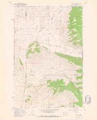
1964 Map of Niarada
USGS Topo · Published 1967About this map
Niarada sits at the base of the Hog Heaven Range, marking a point of convergence for the borders of Sanders, Flathead, and Lake Counties. This mid-1960s survey reveals a landscape of high-altitude drainages and rural infrastructure, including a Battle Butte Sch and a lone Cem tucked near the county lines. The western slopes are defined by Sullivan Hill and the winding course of Sullivan Creek, which flows through an area marked by historic land divisions and small-scale operations like a local Gravel Pit. The map captures the transition from the steep, forested elevations of the range to the lower grazing lands and water sources essential for local agriculture. Traces of early transportation remain visible through the network of mountain roads and a Jeep Trail that climbs through the southern draws near Rattlesnake Gulch.
Find a feature on this map
19 named features on this map. Tap any name to fly to it.
Don’t see what you’re looking for? This feature index may not catch every label — zoom into the map to look around manually.
Map Details
Editions of this 1964 Niarada Map
This is the sole edition of this map. No revisions or reprints were ever made.
Other maps of this area

1920 · Flathead Lake
USGS Topo · 1:125,000

1956 · Wallace
USGS Topo · 1:250,000

1960 · Wallace
USGS Topo · 1:250,000

1964 · Irvine Lookout Tower
USGS Topo · 1:24,000
1964 · Lake Mary Ronan
USGS Topo · 1:24,000

1964 · Mill Pocket Creek
USGS Topo · 1:24,000
1964 · Kofford Ridge
USGS Topo · 1:24,000

1964 · Hubbart Reservoir
USGS Topo · 1:24,000

1964 · Lonepine
USGS Topo · 1:24,000
1964 · Hot Springs NE
USGS Topo · 1:24,000