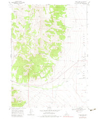
1968 Map of Nibbs Creek
USGS Topo · Published 1983About this map
The Cotterel Mountains and the Jim Sage Mountains dominate this high-desert landscape in southern Idaho, separated by the basin of Cassia Creek. This late-1960s survey captures a transition between the mountain ranges and the agricultural Raft River Valley to the east. Water sources are critical identifiers in this arid environment, with numerous family-named and geographic springs such as McClenden Spring, Nibbs Spring, and Cow Gulch Spring marking the base of the mountain slopes.
Find a feature on this map
23 named features on this map. Tap any name to fly to it.
Don’t see what you’re looking for? This feature index may not catch every label — zoom into the map to look around manually.
Map Details
Editions of this 1968 Nibbs Creek Map
2 editions found
Other maps of this area

1954 · Pocatello
USGS Topo · 1:250,000

1958 · Pocatello
USGS Topo · 1:250,000

1968 · Malta NE
USGS Topo · 1:24,000

1968 · Malta
USGS Topo · 1:24,000

1968 · Idahome
USGS Topo · 1:24,000

1968 · Elba
USGS Topo · 1:24,000

1968 · Kane Canyon
USGS Topo · 1:24,000

1968 · Nibbs Creek
USGS Topo · 1:24,000

1968 · Albion
USGS Topo · 1:24,000
1968 · Connor Ridge
USGS Topo · 1:24,000