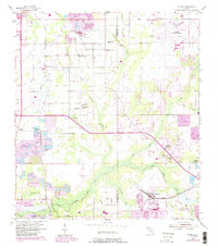
1955 Map of Nichols
USGS Topo · Published 1988About this map
Phosphate mining and agricultural development define the landscape along the Hillsborough and Polk County line during the mid-20th century. The settlement of Nichols sits at the heart of industrial activity, surrounded by extensive areas of Reclaimed Strip Mine and a dedicated Mine Dump. To the north, the community of Coronet is situated near a golf course and additional strip mines, illustrating the region's economic reliance on mineral extraction.
Find a feature on this map
46 named features on this map. Tap any name to fly to it.
Don’t see what you’re looking for? This feature index may not catch every label — zoom into the map to look around manually.
Map Details
Editions of this 1955 Nichols Map
4 editions found
Other maps of this area

1944 · Plant City
USGS Topo · 1:31,680

1944 · Lakeland
USGS Topo · 1:31,680

1944 · Antioch
USGS Topo · 1:31,680

1949 · Mulberry
USGS Topo · 1:24,000

1949 · Bradley Junction
USGS Topo · 1:24,000

1950 · Mulberry
USGS Topo · 1:24,000

1950 · Bradley Junction
USGS Topo · 1:24,000

1955 · Lithia
USGS Topo · 1:24,000

1955 · Nichols
USGS Topo · 1:24,000

1955 · Dover
USGS Topo · 1:24,000