
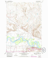
1968 Map of Nichols
USGS Topo · Published 1972About this map
The Yellowstone River meanders through a broad floodplain at the junction of Hammond Valley and Howard Valley, defining the geographic character of this Rosebud County landscape. In the late 1960s, the area's transportation infrastructure was dominated by two major competing rail lines: the Chicago Milwaukee St Paul and Pacific running north of the river and the Burlington Northern skirting the southern bluffs through the settlement of Nichols.
Find a feature on this map
17 named features on this map. Tap any name to fly to it.
Don’t see what you’re looking for? This feature index may not catch every label — zoom into the map to look around manually.
Map Details
Editions of this 1968 Nichols Map
2 editions found
Other maps of this area

1954 · Forsyth
USGS Topo · 1:250,000

1957 · Forsyth
USGS Topo · 1:250,000

1958 · Forsyth
USGS Topo · 1:250,000

1968 · Donleys Reservoir
USGS Topo · 1:24,000

1968 · Forsyth
USGS Topo · 1:24,000

1968 · Finch NE
USGS Topo · 1:24,000

1968 · Black Coulee
USGS Topo · 1:24,000

1968 · Finch
USGS Topo · 1:24,000

1971 · Griffin Coulee NE
USGS Topo · 1:24,000
1971 · Smith Creek
USGS Topo · 1:24,000