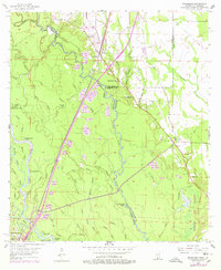
1955 Map of Nicholson
USGS Topo · Published 1978About this map
The Pearl River forms a complex, winding boundary between St Tammany Parish, Louisiana, and Pearl River County, Mississippi, in this mid-century survey. The landscape is defined by an intricate network of waterways, including Indian Bayou, Little Black Bayou, and Crooked Bayou, which carve through the low-lying terrain near Porters Island. Settlement is clustered around the Southern railroad line, with Nicholson serving as a focal point. On the eastern edge, the industrial footprint of the Test Facility (NASA) appears in later revisions, contrasting with the rural character of nearby Santa Rosa. Genealogists will find several community hubs such as Red Hill Ch, Cedar Grove Ch, and Turtleskin Cem. The transition from river bottomlands to the gravel-rich uplands is marked by numerous Gravel Pits, illustrating the local extractive economy.
Find a feature on this map
64 named features on this map. Tap any name to fly to it.
Don’t see what you’re looking for? This feature index may not catch every label — zoom into the map to look around manually.
Map Details
Editions of this 1955 Nicholson Map
5 editions found

Other maps of this area

1914 · Nicholson
USGS Topo · 1:62,500

1921 · Nicholson
USGS Topo · 1:62,500

1935 · Slidell
USGS Topo · 1:62,500

1939 · Slidell
USGS Topo · 1:62,500

1941 · Honey Island
USGS Topo · 1:31,680

1942 · Walkiah Bluff
USGS Topo · 1:31,680

1950 · Haaswood
USGS Topo · 1:31,680

1950 · Slidell
USGS Topo · 1:62,500

1953 · Mobile
USGS Topo · 1:250,000

1954 · Haaswood
USGS Topo · 1:31,680