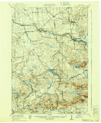
1921 Map of Nicholville
USGS Topo · Published 1939About this map
St Regis River and its branches serve as the primary geographical focus for this part of northern New York, connecting the riverside settlements of Nicholville and St Regis Falls. Surveyed in 1919, the map reveals a rural landscape organized around a dense network of district schoolhouses, from School No 8 near the Turnpike to the Lake Ozonia School deep in the Adirondack foothills. The northern lowlands are characterized by small hamlets like Fort Jackson and Dickinson Center, while the southern terrain rises into a complex system of peaks and high-altitude water bodies, including Lake Ozonia and Dexter Lake. The inclusion of specific industry landmarks such as Days Mill and the Cooperage Club, alongside various lumbering-related routes like Cooperage Road, points to an economy deeply rooted in timber and milling during this era.
Find a feature on this map
84 named features on this map. Tap any name to fly to it.
Don’t see what you’re looking for? This feature index may not catch every label — zoom into the map to look around manually.
Map Details
Editions of this 1921 Nicholville Map
4 editions found

Other maps of this area

1905 · Saint Regis
USGS Topo · 1:62,500

1906 · Massena
USGS Topo · 1:62,500

1907 · Massena
USGS Topo · 1:62,500

1908 · Potsdam
USGS Topo · 1:62,500

1915 · Malone
USGS Topo · 1:62,500

1915 · Moira
USGS Topo · 1:62,500

1917 · Malone
USGS Topo · 1:62,500

1917 · Moira
USGS Topo · 1:62,500

1919 · Nicholville
USGS Topo · 1:62,500

1920 · Childwold
USGS Topo · 1:62,500