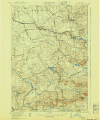
1921 Map of Nicholville
USGS Topo · Published 1940About this map
Nicholville and the surrounding township of Hopkinton are defined by the powerful descent of the St Regis River and its multiple branches as they flow toward the St. Lawrence Lowlands. Surveyed shortly after the First World War, this landscape captures a network of rural school districts, including the Water Street School and State Road School, which served dispersed farming communities. The industrial character of the era is evident at St Regis Falls and Days Mill, where water power fueled local economy. To the south, the terrain rises into the Adirondack Park, transitioning from the grid-like roads of Lawrence and Dickinson into the dense topography of Miners Hill and Bear Mtn. This area near Lake Ozonia shows early recreation and logging influences, marked by the Cooperage Club and the winding Cooperage Road.
Find a feature on this map
90 named features on this map. Tap any name to fly to it.
Don’t see what you’re looking for? This feature index may not catch every label — zoom into the map to look around manually.
Map Details
Editions of this 1921 Nicholville Map
4 editions found

Other maps of this area

1905 · Saint Regis
USGS Topo · 1:62,500

1906 · Massena
USGS Topo · 1:62,500

1907 · Massena
USGS Topo · 1:62,500

1908 · Potsdam
USGS Topo · 1:62,500

1915 · Malone
USGS Topo · 1:62,500

1915 · Moira
USGS Topo · 1:62,500

1917 · Malone
USGS Topo · 1:62,500

1917 · Moira
USGS Topo · 1:62,500

1919 · Nicholville
USGS Topo · 1:62,500

1920 · Childwold
USGS Topo · 1:62,500