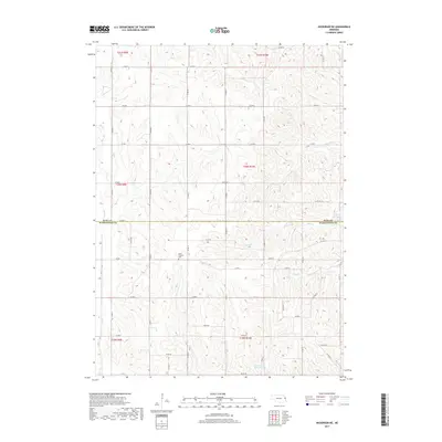
2017 Map of Nickerson NE
USGS Topo · Published 2017About this map
The boundary between Burt and Washington Counties divides this agricultural landscape, where a dense network of sectional roads connects isolated farmsteads across the Nebraska plains. This part of the state exhibits a distinctive drainage pattern defined by numerous small creeks, including Bell Creek and New York Creek, which carve gentle valleys through the terrain. The central focal point for local history is the New England Cem, situated near the intersection of several county routes. Water management is evident in the presence of man-made impoundments like Skinner Reservoir and Cameron Reservoir, which support the region's farming economy. The map reveals the precise grid system of the Great Plains, with roads like Co RD 4 and Co RD 15 forming the primary infrastructure for this rural community.
Find a feature on this map
49 named features on this map. Tap any name to fly to it.
Don’t see what you’re looking for? This feature index may not catch every label — zoom into the map to look around manually.
Map Details
Editions of this 2017 Nickerson NE Map
This is the sole edition of this map. No revisions or reprints were ever made.
Other maps of this area

1955 · Fremont
USGS Topo · 1:250,000

1957 · Fremont
USGS Topo · 1:250,000

1958 · Fremont
USGS Topo · 1:250,000

1966 · Oakland
USGS Topo · 1:24,000

1966 · Nickerson
USGS Topo · 1:24,000

1966 · Nickerson NW
USGS Topo · 1:24,000
1969 · Orum
USGS Topo · 1:24,000

1970 · Oakland SE
USGS Topo · 1:24,000

1970 · Herman
USGS Topo · 1:24,000
1970 · Nickerson NE
USGS Topo · 1:24,000