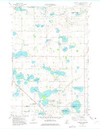
1973 Map of Niemackl Lakes
USGS Topo · Published 1975About this map
The Niemackl Lakes and their surrounding wetlands define this prairie landscape in west-central Minnesota, where the borders of Delaware, Macsville, and Donnelly townships meet. The area is characterized by an extensive network of water bodies and conservation lands, including the Macsville State Wildlife Management Area and several designated National Waterfowl Production Area sites. The Mustinka Flowage, controlled by the Mustinka Dam in the northwest, feeds into a glaciated terrain dotted with named basins like Big Lake, Cottonwood Lake, and Ohlsrud Lake.
Find a feature on this map
38 named features on this map. Tap any name to fly to it.
Don’t see what you’re looking for? This feature index may not catch every label — zoom into the map to look around manually.
Map Details
Editions of this 1973 Niemackl Lakes Map
This is the sole edition of this map. No revisions or reprints were ever made.
Other maps of this area

1910 · Chokio
USGS Topo · 1:62,500

1911 · Barrett
USGS Topo · 1:62,500

1911 · Herman
USGS Topo · 1:62,500

1912 · Chokio
USGS Topo · 1:62,500

1912 · Morris
USGS Topo · 1:62,500

1953 · Milbank
USGS Topo · 1:250,000

1953 · Saint Cloud
USGS Topo · 1:250,000

1957 · Saint Cloud
USGS Topo · 1:250,000

1958 · Milbank
USGS Topo · 1:250,000

1958 · Saint Cloud
USGS Topo · 1:250,000