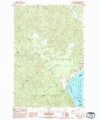
1985 Map of Ninemile Flat
USGS Topo · Published 1994About this map
The Colville Indian Reservation dominates this 1980s landscape, where the high country of Gold Mountain Ridge descends into the broad Ninemile Flat near the eastern boundary of Ferry County. The terrain is defined by a dense network of drainages, including the South Fork and Little Ninemile Creek, which flow toward the massive expanse of Franklin D Roosevelt Lake. This impoundment of the Columbia River forms a significant portion of the Coulee Dam National Recreation Area, altering the original riverine environment into a vast reservoir system.
Find a feature on this map
22 named features on this map. Tap any name to fly to it.
Don’t see what you’re looking for? This feature index may not catch every label — zoom into the map to look around manually.
Map Details
Editions of this 1985 Ninemile Flat Map
3 editions found
Other maps of this area

1948 · Wilbur
USGS Topo · 1:62,500

1948 · Wilmont Creek
USGS Topo · 1:62,500

1948 · Lincoln
USGS Topo · 1:62,500

1950 · Lincoln
USGS Topo · 1:62,500

1950 · Wilmont Creek
USGS Topo · 1:62,500

1950 · Wilbur
USGS Topo · 1:62,500

1952 · Keller
USGS Topo · 1:62,500

1953 · Ritzville
USGS Topo · 1:250,000

1954 · Okanogan
USGS Topo · 1:250,000

1956 · Wilmont Creek
USGS Topo · 1:62,500