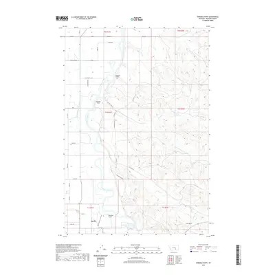
2020 Map of Ninemile Point
USGS Topo · Published 2020About this map
The Bighorn River snakes through this landscape, defining the agricultural and industrial character of the region. Just north of Hardin, the river's path is shadowed by the Big Horn Low Line Canal, an essential piece of water infrastructure for the surrounding valley. The topography is marked by several significant drainage features, including Chapman Coulee and Whitman Coulee, which cut through the benchlands toward the river valley. Near the southern edge of the map, the Arapooish Pond sits near the riverbanks, likely serving as a local landmark for those navigating the area around the Hardin Generation Station Rd. To the east, the terrain rises into more broken country characterized by ridges and distinctive formations like Hive Butte and the winding course of Ninemile Creek. This survey provides a clear view of the rural road network, including family and local names like Kerns Rd and Schultz Rd.
Find a feature on this map
48 named features on this map. Tap any name to fly to it.
Don’t see what you’re looking for? This feature index may not catch every label — zoom into the map to look around manually.
Map Details
Editions of this 2020 Ninemile Point Map
This is the sole edition of this map. No revisions or reprints were ever made.
Other maps of this area

1894 · Fort Custer
USGS Topo · 1:125,000

1954 · Hardin
USGS Topo · 1:250,000

1957 · Hardin
USGS Topo · 1:250,000

1958 · Hardin
USGS Topo · 1:250,000

1960 · Foster
USGS Topo · 1:24,000

1960 · Ninemile Point
USGS Topo · 1:24,000

1960 · Chimney Creek
USGS Topo · 1:24,000

1960 · Walker Hill
USGS Topo · 1:24,000

1960 · Hardin
USGS Topo · 1:24,000
1960 · Lemon Ranch
USGS Topo · 1:24,000