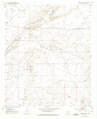
1951 Map of Ninemile Well
USGS Topo · Published 1975About this map
Long Arroyo carves a path through this section of the New Mexico landscape, illustrating the critical importance of water management in a ranching-driven economy. Based on topography from 1951, the map highlights the distribution of named homesteads and essential infrastructure that sustained cattle operations in Chaves County. Established family holdings like Greer Ranch and King Ranch are positioned near drainage features, while the prevalence of isolated water sources such as Ninemile Well and Rattlesnake Windmill speaks to the necessity of dispersed wells across the semi-arid terrain. In the southern portion, Buffalo Valley and Buffalo Valley Derrick Draw mark the transition toward lower ground. For historians and genealogists, these specific ranch names like Derrick Ranch, Haynes Ranch, and Calhoun Ranch provide a primary record of land tenure and residency in the mid-century period before significant modernization altered the rural character of the region.
Find a feature on this map
12 named features on this map. Tap any name to fly to it.
Don’t see what you’re looking for? This feature index may not catch every label — zoom into the map to look around manually.
Map Details
Editions of this 1951 Ninemile Well Map
3 editions found
Other maps of this area

1950 · Dexter East
USGS Topo · 1:24,000

1951 · Ninemile Well
USGS Topo · 1:24,000

1951 · King Camp
USGS Topo · 1:24,000

1951 · Diamond Mound
USGS Topo · 1:24,000

1951 · Hagerman
USGS Topo · 1:24,000

1952 · Connor Well
USGS Topo · 1:24,000

1952 · Bar C Bar Ranch
USGS Topo · 1:24,000

1953 · Basin Well
USGS Topo · 1:24,000

1954 · Carlsbad
USGS Topo · 1:250,000

1955 · Artesia NE
USGS Topo · 1:24,000