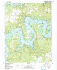
1991 Map of Ninnescah Park
USGS Topo · Published 1991About this map
The Harry S Truman Reservoir dominates this central Missouri landscape, where the confluence of the Grand River and Osage River has been transformed into a complex network of bays and peninsulas. The 1991 survey shows the sprawling reach of the water into local drainages like Hogles Creek and Wright Creek, significantly altering the topography of the Osage and Butler townships.
Find a feature on this map
33 named features on this map. Tap any name to fly to it.
Don’t see what you’re looking for? This feature index may not catch every label — zoom into the map to look around manually.
Map Details
Editions of this 1991 Ninnescah Park Map
This is the sole edition of this map. No revisions or reprints were ever made.
Other maps of this area

1887 · Clinton
USGS Topo · 1:125,000

1887 · Warsaw
USGS Topo · 1:125,000

1894 · Warsaw
USGS Topo · 1:125,000

1894 · Clinton
USGS Topo · 1:125,000

1936 · Shawnee Bend
USGS Topo · 1:24,000

1939 · Osceola
USGS Topo · 1:24,000

1940 · Osceola
USGS Topo · 1:24,000

1940 · Iconium
USGS Topo · 1:24,000

1941 · Valhalla
USGS Topo · 1:24,000

1941 · Lowry City
USGS Topo · 1:24,000