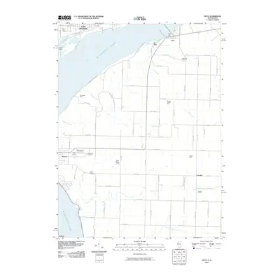
2010 Map of Niota
USGS Topo · Published 2010About this map
The Mississippi River dominates this landscape, serving as the border between Fort Madison and the Illinois settlements of Niota and Old Niota. This 2010 survey illustrates the transport infrastructure of the region, anchored by the BNSF Railway corridor and local aviation sites like Winchester Airport and Cedar Ridge Airport. The geography is defined by numerous drainage systems, including Tyson Creek, Robinson Creek, and Sheridan Creek, which cut through the agricultural tablelands of Hancock County.
Find a feature on this map
71 named features on this map. Tap any name to fly to it.
Don’t see what you’re looking for? This feature index may not catch every label — zoom into the map to look around manually.
Map Details
Editions of this 2010 Niota Map
This is the sole edition of this map. No revisions or reprints were ever made.
Other maps of this area

1932 · Lomax
USGS Topo · 1:62,500

1933 · Carthage
USGS Topo · 1:62,500

1936 · Keokuk
USGS Topo · 1:62,500

1936 · Fort Madison
USGS Topo · 1:62,500

1937 · Carthage
USGS Topo · 1:62,500

1937 · Lomax
USGS Topo · 1:62,500

1950 · Keokuk
USGS Topo · 1:62,500

1958 · Burlington
USGS Topo · 1:250,000

1961 · Burlington
USGS Topo · 1:250,000

1963 · Burlington
USGS Topo · 1:250,000