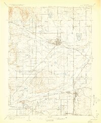
1904 Map of Niwot
USGS Topo · Published 1923About this map
Longmont serves as the primary hub of this 1902 survey, anchoring an agricultural and industrial landscape where the plains meet the foothills. The region's development is driven by a complex irrigation network, including the Supply Ditch, Highland Ditch, and Oligarchy Ditch, which transformed the arid terrain into productive farmland. Settlement patterns follow the competing paths of the Colorado and Southern R. R. and the Burlington and Missouri River R. R., connecting towns like Hygiene, Niwot, and Erie. To the south, coal mining operations at the Gladstone Mine and Hayward Mine underscore the transition from farming to resource extraction near the Weld and Adams county line. Prominent landmarks such as Gunbarrel Hill and Valmont Butte provide navigation points across the rolling topography, while Dixon Mill on the St. Vrain Creek highlights early water-powered industry in the valley.
Find a feature on this map
69 named features on this map. Tap any name to fly to it.
Don’t see what you’re looking for? This feature index may not catch every label — zoom into the map to look around manually.
Map Details
Editions of this 1904 Niwot Map
3 editions found
Other maps of this area

1890 · East Denver
USGS Topo · 1:125,000

1899 · West Denver
USGS Topo · 1:125,000

1902 · Greeley
USGS Topo · 1:125,000

1902 · Boulder
USGS Topo · 1:62,500

1904 · Niwot
USGS Topo · 1:62,500

1904 · Boulder
USGS Topo · 1:62,500

1905 · Mount Olympus
USGS Topo · 1:62,500

1906 · Blackhawk
USGS Topo · 1:62,500

1906 · Loveland
USGS Topo · 1:62,500

1907 · Mount Olympus
USGS Topo · 1:62,500