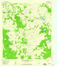
1959 Map of Nix
USGS Topo · Published 1960About this map
The small rural settlement of Nix sits at the crossroads of Lampasas County in the late 1950s, serving as a quiet focal point for a landscape defined by rolling hills and creek beds. The map captures a transition in water management with the presence of several reservoirs, including Reservoir No 1 and Reservoir No 2, situated alongside historic watercourses like Donalson Creek and Hughes Creek. Evidence of local community life is preserved through the locations of the McCreaville Ch and the Pitt Creek Cem, the latter located near Pitt Hollow. The topography is marked by distinctive elevations such as Waters Mountain and Cedar Top Peak, while the southern portion of the sheet reveals the Lampasas Co Burnet Co line, providing a clear view of the jurisdictional boundaries and land use patterns of the era.
Find a feature on this map
27 named features on this map. Tap any name to fly to it.
Don’t see what you’re looking for? This feature index may not catch every label — zoom into the map to look around manually.
Map Details
Editions of this 1959 Nix Map
2 editions found
Other maps of this area

1887 · Lampasas
USGS Topo · 1:125,000

1887 · Burnet
USGS Topo · 1:125,000

1893 · Burnet
USGS Topo · 1:125,000

1894 · Lampasas
USGS Topo · 1:125,000

1903 · Burnet
USGS Topo · 1:125,000

1909 · Burnet
USGS Topo · 1:125,000

1932 · Tow
USGS Topo · 1:62,500

1954 · Brownwood
USGS Topo · 1:250,000

1954 · Lampasas
USGS Topo · 1:62,500

1954 · Lampasas
USGS Topo · 1:24,000