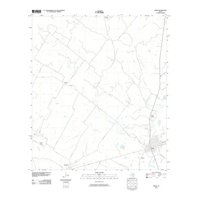
2010 Map of Nixon
USGS Topo · Published 2010About this map
The town of Nixon anchors the southeast corner of this survey, where a network of rural roads extends into the agricultural landscape of Gonzales County. The terrain is defined by the winding course of Clear Fork Creek and its various tributaries, including Nose Creek and Tally Branch, which drain towards the larger Ecleto Creek in the southwest. Small settlements like Pandora and Union are connected by a series of Farm to Market roads and county routes that trace the historical development of these farming communities.
Find a feature on this map
43 named features on this map. Tap any name to fly to it.
Don’t see what you’re looking for? This feature index may not catch every label — zoom into the map to look around manually.
Map Details
Editions of this 2010 Nixon Map
This is the sole edition of this map. No revisions or reprints were ever made.
Other maps of this area

1920 · Smiley
USGS Topo · 1:125,000

1942 · Dewville
USGS Topo · 1:62,500

1953 · Seguin
USGS Topo · 1:250,000

1956 · Dewville
USGS Topo · 1:62,500

1958 · Seguin
USGS Topo · 1:250,000

1961 · Nixon
USGS Topo · 1:24,000
1961 · Stockdale
USGS Topo · 1:24,000
1961 · Thomas Springs
USGS Topo · 1:24,000
1961 · Alum
USGS Topo · 1:24,000

1961 · Gillett
USGS Topo · 1:24,000