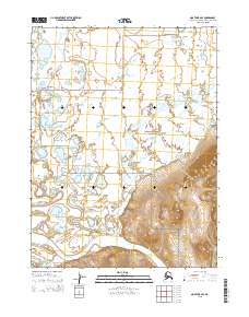
2015 Map of Noatak B-2 SE
USGS Topo · Published 2015About this map
The Noatak National Preserve encompasses a significant portion of this Arctic landscape, where the braided channels of the Noatak River meet the rising slopes of the Igichuk Hills. This 2015 topographical study documents the intricate hydrology of the region, specifically where the Agashashok River flows south into the main river channel. The northern half of the map is defined by a dense network of seasonal wetlands and small lakes characteristic of the tundra, while the southern section transitions into more defined relief.
Find a feature on this map
11 named features on this map. Tap any name to fly to it.
Don’t see what you’re looking for? This feature index may not catch every label — zoom into the map to look around manually.
Map Details
Editions of this 2015 Noatak B-2 SE Map
This is the sole edition of this map. No revisions or reprints were ever made.
Other maps of this area

1951 · Noatak
USGS Topo · 1:250,000

1955 · Noatak
USGS Topo · 1:250,000

1955 · Noatak B-2
USGS Topo · 1:63,360
1955 · Noatak A-1
USGS Topo · 1:63,360
1955 · Noatak A-2
USGS Topo · 1:63,360
1955 · Noatak B-1
USGS Topo · 1:63,360

1964 · Noatak
USGS Topo · 1:250,000
2015 · Noatak A-1 NW
USGS Topo · 1:25,000
2015 · Noatak B-1 NW
USGS Topo · 1:25,000
2015 · Noatak B-2 SW
USGS Topo · 1:25,000