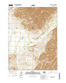
2015 Map of Noatak C-1 NE
USGS Topo · Published 2015About this map
Maiyumerak Mountains dominate the northern landscape of this remote Arctic interior, providing a stark topographical contrast to the winding path of the Eli River. This waterway meanders westward through the central portion of the sheet, carving a valley floor that crosses into the protected boundaries of the Noatak National Preserve. The transition from the high relief of the mountains to the river basin illustrates the drainage patterns characteristic of the Northwest Arctic region. Surveyed by the U.S. Geological Survey, the map details the Public Land Survey System grids, including t27n r16w and t26n r15w, which provide the underlying structure for land management in this wilderness area where natural features define the only discernible boundaries.
Find a feature on this map
7 named features on this map. Tap any name to fly to it.
Don’t see what you’re looking for? This feature index may not catch every label — zoom into the map to look around manually.
Map Details
Editions of this 2015 Noatak C-1 NE Map
This is the sole edition of this map. No revisions or reprints were ever made.
Other maps of this area

1951 · Baird Mountains
USGS Topo · 1:250,000

1951 · Noatak
USGS Topo · 1:250,000

1955 · Noatak
USGS Topo · 1:250,000

1955 · Noatak D-1
USGS Topo · 1:63,360

1955 · Baird Mountains D-6
USGS Topo · 1:63,360

1955 · Noatak C-1
USGS Topo · 1:63,360
1955 · Baird Mountains C-6
USGS Topo · 1:63,360

1956 · Baird Mountains
USGS Topo · 1:250,000

1964 · Noatak
USGS Topo · 1:250,000

1965 · Baird Mountains
USGS Topo · 1:250,000