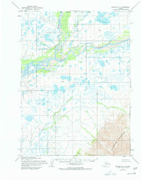
1955 Map of Noatak D-1
USGS Topo · Published 1978About this map
The Noatak River dominates this mid-century landscape, carving a wide alluvial path through the northern Alaskan wilderness. The confluence of the Kelly River and Avan River illustrates a complex drainage network typical of the Brooks Range foothills, where seasonal shifts reshape the gravel bars and braided channels. In the southern portion of the quadrangle, the Maiyumerak Mountains rise sharply, providing a stark topographical contrast to the lake-dotted lowlands to the north. A solitary Cabin along the Noatak provides the only evidence of human habitation in this 1950s survey, likely serving as a seasonal waypoint for hunters or travelers. To the north, Lake Tagakvik anchors a cluster of tundra lakes, while the southern drainage of Uvgoon Creek flows toward the rugged heights of the Ridge. This map captures a landscape defined by its waterways and mountain passes prior to later administrative revisions.
Find a feature on this map
9 named features on this map. Tap any name to fly to it.
Don’t see what you’re looking for? This feature index may not catch every label — zoom into the map to look around manually.
Map Details
Editions of this 1955 Noatak D-1 Map
3 editions found
Other maps of this area

1951 · De Long Mountains
USGS Topo · 1:250,000

1951 · Baird Mountains
USGS Topo · 1:250,000

1951 · Noatak
USGS Topo · 1:250,000

1951 · Misheguk Mountain
USGS Topo · 1:250,000

1955 · Noatak
USGS Topo · 1:250,000

1955 · De Long Mountains
USGS Topo · 1:250,000

1955 · Noatak D-1
USGS Topo · 1:63,360

1955 · Noatak D-2
USGS Topo · 1:63,360

1955 · Baird Mountains D-6
USGS Topo · 1:63,360

1955 · Misheguk Mountain A-5
USGS Topo · 1:63,360