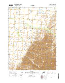
2015 Map of Noatak D-1 SE
USGS Topo · Published 2015About this map
The Noatak National Preserve occupies much of this landscape, where the northern Arctic wilderness transitions into the high elevations of the Maiyumerak Mountains. The map reveals a complex drainage system defined by Uvgoon Cr, which snakes through the foothills and low-lying areas. The terrain is marked by a sharp contrast between the broad, relatively flat river basins and the steep, tightly packed contour lines of the southern mountain range, which dominates the lower half of the quadrangle. As a modern survey, it serves as a precise record of the hydrological patterns and topographic relief within this federally protected area of the Northwest Arctic borough.
Find a feature on this map
9 named features on this map. Tap any name to fly to it.
Don’t see what you’re looking for? This feature index may not catch every label — zoom into the map to look around manually.
Map Details
Editions of this 2015 Noatak D-1 SE Map
This is the sole edition of this map. No revisions or reprints were ever made.
Other maps of this area

1951 · Baird Mountains
USGS Topo · 1:250,000

1951 · Noatak
USGS Topo · 1:250,000

1955 · Noatak
USGS Topo · 1:250,000

1955 · Noatak D-1
USGS Topo · 1:63,360

1955 · Baird Mountains D-6
USGS Topo · 1:63,360

1955 · Noatak C-1
USGS Topo · 1:63,360
1955 · Baird Mountains C-6
USGS Topo · 1:63,360

1956 · Baird Mountains
USGS Topo · 1:250,000

1964 · Noatak
USGS Topo · 1:250,000

1965 · Baird Mountains
USGS Topo · 1:250,000