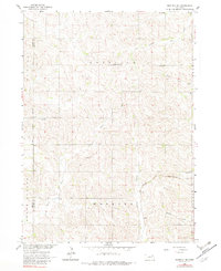
1963 Map of Norfolk NE
USGS Topo · Published 1982About this map
Wayne County and Pierce County farmlands are defined by a network of drainage basins and rural community centers in this early 1960s study. The topography is shaped by the winding courses of South Logan Creek, Turtle Creek, and Humbug Creek, which carve through the plains of Garfield and Hoskins townships. The map documents the localized infrastructure of the mid-century Midwest, featuring several rural education centers such as Garfield Center Sch and Bellview Sch. Religious life and local genealogy are anchored by the Swedish Cem and Zion Ch in the western half of the quadrangle, while Immanuel Ch and its accompanying Immanuel Cem serve the eastern township. The Chicago and North Western railroad cuts diagonally through the southeast, providing a vital link for the agricultural transport economy of the era.
Find a feature on this map
20 named features on this map. Tap any name to fly to it.
Don’t see what you’re looking for? This feature index may not catch every label — zoom into the map to look around manually.
Map Details
Editions of this 1963 Norfolk NE Map
2 editions found
Other maps of this area

1955 · Sioux City
USGS Topo · 1:250,000

1958 · Sioux City
USGS Topo · 1:250,000

1959 · Sioux City
USGS Topo · 1:250,000

1963 · Hoskins
USGS Topo · 1:24,000

1963 · Wayne SW
USGS Topo · 1:24,000

1963 · Norfolk
USGS Topo · 1:24,000

1963 · Winside
USGS Topo · 1:24,000

1963 · Wee Town
USGS Topo · 1:24,000

1963 · Norfolk NE
USGS Topo · 1:24,000

1971 · Randolph South
USGS Topo · 1:24,000