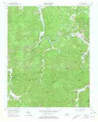
1954 Map of Norma
USGS Topo · Published 1979About this map
The New River carves a winding path through the Cumberland Plateau on this map, serving as the central artery for the timber and coal operations in Scott County. High ridges like Cordell Mountain and Day Mountain overlook a landscape transitioning into a mid-century industrial era, where the Tennessee railroad line connects riverside settlements including Norma and Winona. The presence of several Strip Mines and the Lone Min near the Campbell County line illustrates the heavy reliance on extraction during the 1950s. Family history is deeply rooted here, evidenced by several small plots such as the Rector Cem and Rob Sexton Cem. Along the creek bottoms, communities were anchored by institutions like the Smoky Creek Sch and Mill Branch Ch, while Lookout Tower No 16 on Signal Mtn stood watch over the heavily forested peaks.
Find a feature on this map
73 named features on this map. Tap any name to fly to it.
Don’t see what you’re looking for? This feature index may not catch every label — zoom into the map to look around manually.
Map Details
Editions of this 1954 Norma Map
4 editions found
Other maps of this area

1893 · Briceville
USGS Topo · 1:125,000

1895 · Wartburg
USGS Topo · 1:125,000

1895 · Briceville
USGS Topo · 1:125,000

1896 · Wartburg
USGS Topo · 1:125,000

1896 · Briceville
USGS Topo · 1:125,000

1935 · Gobey
USGS Topo · 1:24,000

1936 · Hogbell Gap
USGS Topo · 1:24,000

1936 · Block
USGS Topo · 1:24,000

1936 · Pioneer
USGS Topo · 1:24,000

1936 · Duncan Flats
USGS Topo · 1:24,000