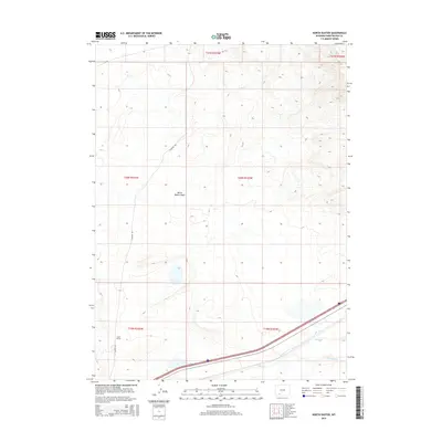
2015 Map of North Baxter
USGS Topo · Published 2015About this map
North Baxter Basin dominates this landscape in Sweetwater County, providing a clear view of the high desert topography of south-central Wyoming. The small settlement of North Baxter is situated along the corridor of N Baxter Rd, reflecting the sparse but enduring ranching and energy-related infrastructure of the region. The southern edge of the survey is defined by the drainage of Bitter Cr, where the Interstate 80 and rail corridor cut through the arid terrain, joined by the confluence of Salt Wells Cr. This map documents the intersection of modern transportation routes with the traditional geographic features of the Baxter Basin area, illustrating how the built environment adheres to the natural contours of the high plains.
Find a feature on this map
11 named features on this map. Tap any name to fly to it.
Don’t see what you’re looking for? This feature index may not catch every label — zoom into the map to look around manually.
Map Details
Editions of this 2015 North Baxter Map
This is the sole edition of this map. No revisions or reprints were ever made.
Other maps of this area

1908 · Rock Springs
USGS Topo · 1:62,500

1910 · Rock Springs
USGS Topo · 1:62,500

1954 · Rock Springs
USGS Topo · 1:250,000

1958 · Rock Springs
USGS Topo · 1:250,000

1958 · Boars Tusk
USGS Topo · 1:62,500

1958 · Superior
USGS Topo · 1:62,500

1962 · Rock Springs
USGS Topo · 1:250,000

1968 · North Baxter
USGS Topo · 1:24,000

1968 · Point Of Rocks SW
USGS Topo · 1:24,000
1968 · Rock Springs
USGS Topo · 1:24,000