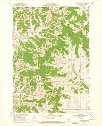
1969 Map of North Bend NE
USGS Topo · Published 1972About this map
Franklin and the outskirts of Melrose define this pocket of Jackson County during the late 1960s, a landscape deeply carved by the drainage of Beaver Creek and its many tributaries. The area's social and historical geography is anchored by rural landmarks such as the Upper Beaver Creek Ch and the Franklin Cem, serving a community settled along winding coulees and ridges. The map illustrates a network of rural roads, including Aleckson Road and Columbus Road, which follow the natural contours of the land rather than a strict grid.
Find a feature on this map
32 named features on this map. Tap any name to fly to it.
Don’t see what you’re looking for? This feature index may not catch every label — zoom into the map to look around manually.
Map Details
Editions of this 1969 North Bend NE Map
This is the sole edition of this map. No revisions or reprints were ever made.
Other maps of this area

1924 · Black River Falls
USGS Topo · 1:62,500

1926 · Black River Falls
USGS Topo · 1:62,500

1926 · North Bend
USGS Topo · 1:62,500

1927 · Blair
USGS Topo · 1:62,500

1928 · Melrose
USGS Topo · 1:48,000

1929 · North Bend
USGS Topo · 1:62,500

1949 · Melrose
USGS Topo · 1:62,500

1953 · Eau Claire
USGS Topo · 1:250,000

1958 · Eau Claire
USGS Topo · 1:250,000

1964 · Eau Claire
USGS Topo · 1:250,000