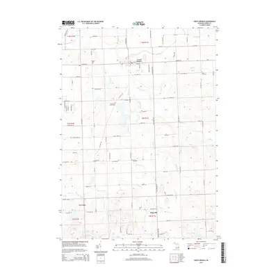
2014 Map of North Branch
USGS Topo · Published 2014About this map
The village of North Branch serves as the focal point of this Lapeer County landscape, where the N Br Flint River and its numerous agricultural drainage systems define the local geography. The map reveals a high concentration of burial grounds, providing significant value for genealogists through sites like Saints Peter and Paul Cem, Maple Grove Cem, and Westlawn Cem. Further south, the map documents the smaller settlements of Kings Mill and Five Lakes, the latter situated near a cluster of glacial water bodies including Clear Lake and Duperow Lake. This era of documentation shows a mature township grid of roads such as Jefferson Rd and Lake Pleasant Rd, which weave together the many family-named cemeteries and the network of man-made waterways like Almas Drain and Fishell-Drain that support the region's farming heritage.
Find a feature on this map
91 named features on this map. Tap any name to fly to it.
Don’t see what you’re looking for? This feature index may not catch every label — zoom into the map to look around manually.
Map Details
Editions of this 2014 North Branch Map
This is the sole edition of this map. No revisions or reprints were ever made.
Other maps of this area

1954 · Flint
USGS Topo · 1:250,000

1958 · Flint
USGS Topo · 1:250,000

1963 · Clifford
USGS Topo · 1:24,000

1963 · Attica
USGS Topo · 1:24,000

1963 · Mayville
USGS Topo · 1:24,000

1963 · Marlette
USGS Topo · 1:24,000

1963 · North Branch
USGS Topo · 1:24,000

1963 · Burnside
USGS Topo · 1:24,000
1963 · Imlay City
USGS Topo · 1:24,000
1963 · Barnes Lake
USGS Topo · 1:24,000