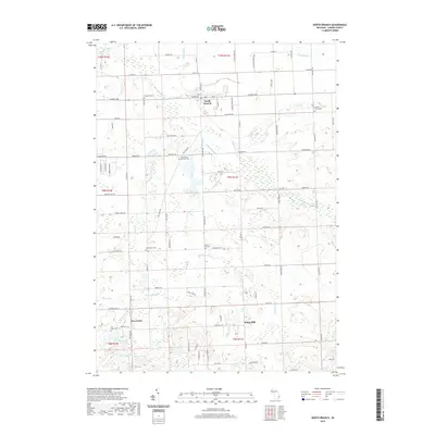
2019 Map of North Branch
USGS Topo · Published 2019About this map
North Branch serves as the primary hub in this portion of Lapeer County, where the N Br Flint River and Elm Cr shape the local drainage. The area's settlement history is preserved through a high density of rural cemeteries, such as Maple Grove Cem and Westlawn Cem, which are often located near long-established section lines and roads like N Branch Rd. To the south, the landscape transitions toward a series of water bodies including Five Lakes, Bear Lake, and Duperow Lake. This region shows a complex network of agricultural drainage, evidenced by named features like Almas Drain and Rockwell Drain, which have facilitated farming across the townships of North Branch and Mayfield for generations. Small community centers such as Kings Mill and Five Lakes remain identifiable landmarks within this interconnected web of county roads and glacial lake beds.
Find a feature on this map
94 named features on this map. Tap any name to fly to it.
Don’t see what you’re looking for? This feature index may not catch every label — zoom into the map to look around manually.
Map Details
Editions of this 2019 North Branch Map
This is the sole edition of this map. No revisions or reprints were ever made.
Other maps of this area

1954 · Flint
USGS Topo · 1:250,000

1958 · Flint
USGS Topo · 1:250,000

1963 · Clifford
USGS Topo · 1:24,000

1963 · Attica
USGS Topo · 1:24,000

1963 · Mayville
USGS Topo · 1:24,000

1963 · Marlette
USGS Topo · 1:24,000

1963 · North Branch
USGS Topo · 1:24,000

1963 · Burnside
USGS Topo · 1:24,000
1963 · Imlay City
USGS Topo · 1:24,000
1963 · Barnes Lake
USGS Topo · 1:24,000