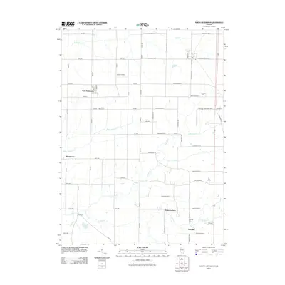
2012 Map of North Henderson
USGS Topo · Published 2012About this map
Rio and North Henderson anchor this agricultural region of Mercer and Knox Counties, where the landscape is defined by the branching tributaries of Henderson Creek. The village of Rio is situated at the intersection of S Main St and E Center Ave, while North Henderson sits to the west along the railroad corridor. The map reveals a dense network of country burial grounds, including the Rio Baptist Cem, Mount Vernon Cem, and Deatherage Cem, which serve as vital markers for local genealogical research. Small, localized settlements like Shanghai City and Soperville persist amidst the section lines, connected by routes such as Knox Highway 34. The terrain is drained by several named waterways, most notably N Henderson Cr, Middle Henderson Cr, and Pennington Cr, which carve subtle valleys through the prairie fields. The Ernest E Orwig Airport provides a localized landmark for aviation history in this rural corridor.
Find a feature on this map
80 named features on this map. Tap any name to fly to it.
Don’t see what you’re looking for? This feature index may not catch every label — zoom into the map to look around manually.
Map Details
Editions of this 2012 North Henderson Map
This is the sole edition of this map. No revisions or reprints were ever made.
Other maps of this area

1921 · Monmouth
USGS Topo · 1:62,500

1923 · Monmouth
USGS Topo · 1:62,500

1923 · Alexis
USGS Topo · 1:62,500

1925 · Alexis
USGS Topo · 1:62,500

1925 · Galesburg
USGS Topo · 1:62,500

1927 · Galesburg
USGS Topo · 1:62,500

1947 · Woodhull
USGS Topo · 1:62,500

1953 · Woodhull
USGS Topo · 1:24,000

1953 · Viola
USGS Topo · 1:24,000
1953 · New Windsor
USGS Topo · 1:24,000