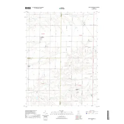
2018 Map of North Henderson
USGS Topo · Published 2018About this map
Rio and North Henderson sit along the western edge of Knox County, where the agricultural prairie begins to break into the drainage basins of the Henderson Creek system. This landscape is defined by its rural cemetery network, which serves as a map of early settlement history. From the Mount Vernon Cem and Deatherage Cem in the central uplands to the Henderson Grove Cem and Soperville Cem in the south, these sites mark the community centers established long before modern consolidation. The terrain is deeply etched by N Henderson Cr, Middle Henderson Cr, and S Henderson Cr, which carve through the grid of section roads like Angling Rd and Moshier Hill Rd. To the west, the tiny settlement of Shanghai City sits near the Mercer County line, while Railroad Pond and Glass Lake provide rare standing water features in this well-drained farming territory.
Find a feature on this map
57 named features on this map. Tap any name to fly to it.
Don’t see what you’re looking for? This feature index may not catch every label — zoom into the map to look around manually.
Map Details
Editions of this 2018 North Henderson Map
This is the sole edition of this map. No revisions or reprints were ever made.
Other maps of this area

1921 · Monmouth
USGS Topo · 1:62,500

1923 · Monmouth
USGS Topo · 1:62,500

1923 · Alexis
USGS Topo · 1:62,500

1925 · Alexis
USGS Topo · 1:62,500

1925 · Galesburg
USGS Topo · 1:62,500

1927 · Galesburg
USGS Topo · 1:62,500

1947 · Woodhull
USGS Topo · 1:62,500

1953 · Woodhull
USGS Topo · 1:24,000

1953 · Viola
USGS Topo · 1:24,000
1953 · New Windsor
USGS Topo · 1:24,000