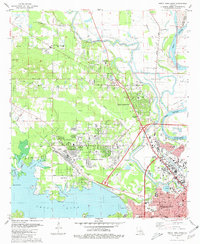
1980 Map of North Highlands
USGS Topo · Published 1981About this map
The northern reaches of Shreveport and the emerging suburb of North Highlands dominate this 1980 landscape, defined by the heavy infrastructure of northern Louisiana. The map reveals a complex web of transport and industry, where the Kansas City Southern and Missouri Pacific railroads converge near the Red River and Twelvemile Bayou. This area serves as a critical education and utility hub, featuring the Southern University (Shreveport-Bossier City Branch), several large high schools like Green Oaks High Sch, and a significant Filtration Plant on the shores of Cross Lake.
Find a feature on this map
65 named features on this map. Tap any name to fly to it.
Don’t see what you’re looking for? This feature index may not catch every label — zoom into the map to look around manually.
Map Details
Editions of this 1980 North Highlands Map
3 editions found
Other maps of this area

1932 · Bossier SW
USGS Topo · 1:31,680

1932 · Shreveport SE
USGS Topo · 1:31,680

1932 · Bossier NW
USGS Topo · 1:31,680

1932 · Shreveport NE
USGS Topo · 1:31,680

1941 · Forbing
USGS Topo · 1:31,680

1945 · Greenwood
USGS Topo · 1:62,500

1948 · Mooringsport
USGS Topo · 1:62,500

1948 · Bossier City
USGS Topo · 1:62,500

1948 · Caspiana
USGS Topo · 1:62,500

1955 · Shreveport
USGS Topo · 1:250,000