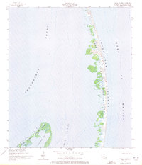
1951 Map of North Islands
USGS Topo · Published 1972About this map
Chandeleur Islands stretch across this mid-century hydrographic and topographic study, showing the fragile barrier island chain as it existed following 1950 aerial photography and 1951 field checks. Much of the land area is protected as part of the Breton National Wildlife Refuge, where shifting sands and marshy outcrops separate the Chandeleur Sound from the open Gulf of Mexico. The map documents the intricate coastline of the North Islands portion of the refuge, featuring the protected waters of Shoalwater Bay and the navigational passage of Smack Channel. This document provides a precise baseline for coastal geologists and environmental historians studying the long-term migration and erosion of Louisiana's easternmost barrier islands before late 20th-century storm cycles further altered the archipelago.
Find a feature on this map
7 named features on this map. Tap any name to fly to it.
Don’t see what you’re looking for? This feature index may not catch every label — zoom into the map to look around manually.
Map Details
Editions of this 1951 North Islands Map
3 editions found
Other maps of this area

1951 · North Islands
USGS Topo · 1:24,000

1951 · New Harbor Islands
USGS Topo · 1:24,000
1951 · Freemason Island
USGS Topo · 1:24,000

1951 · Chandeleur Light
USGS Topo · 1:24,000

1953 · Mobile
USGS Topo · 1:250,000

1957 · Mobile
USGS Topo · 1:250,000

1957 · Breton Sound
USGS Topo · 1:250,000

1960 · Mobile
USGS Topo · 1:250,000

1961 · Breton Sound
USGS Topo · 1:250,000

1963 · Mobile
USGS Topo · 1:250,000