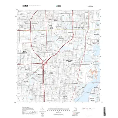
2021 Map of North Miami
USGS Topo · Published 2021About this map
North Miami Beach and its surrounding communities are defined by a sophisticated network of waterways and mid-century urban planning as they appeared in 2021. The landscape is dominated by the Intracoastal Waterway and the Oleta River, where Oleta River State Park preserves a significant pocket of natural terrain amidst the dense residential corridors of Ojus and Aventura. This survey illustrates the intricate relationship between drainage and development, with the Snake Creek Canal and Biscayne Canal cutting through neighborhoods like Ives Estates and Miami Gardens. For local historians and genealogists, the map identifies several major regional landmarks, including Dade Memorial Park, Greater Miami Jewish Cem, and Southern Memorial Park. Educational and civic anchors such as Barry University, the Florida International University Biscayne Bay Campus, and the North Dade Justice Center are precisely located alongside the historic route of the Fec RR.
Find a feature on this map
100 named features on this map. Tap any name to fly to it.
Don’t see what you’re looking for? This feature index may not catch every label — zoom into the map to look around manually.
Map Details
Editions of this 2021 North Miami Map
This is the sole edition of this map. No revisions or reprints were ever made.
Other maps of this area

1947 · North Miami
USGS Topo · 1:24,000

1949 · Opalocka
USGS Topo · 1:24,000

1949 · Port Everglades
USGS Topo · 1:24,000

1949 · Fort Lauderdale South
USGS Topo · 1:24,000

1950 · Hialeah
USGS Topo · 1:24,000

1950 · Miami
USGS Topo · 1:24,000

1950 · North Miami
USGS Topo · 1:24,000

1956 · Miami
USGS Topo · 1:250,000

1956 · West Palm Beach
USGS Topo · 1:250,000

1957 · West Palm Beach
USGS Topo · 1:250,000