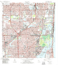
1988 Map of North Miami
USGS Topo · Published 1988About this map
Joe Robbie Stadium stands out as a major landmark in this late-1980s look at the intensifying urban corridor across the Broward Co and Dade Co line. The map documents the rapid expansion of suburban communities such as Miramar, Carol City, and Pembroke Lakes, while preserving older markers of local identity like the Natural Bridge State Historic Site and the historic St Bernard de Clairvaux Church. The landscape is a complex grid of residential developments, including Ives Estates and Biscayne Gardens, interspersed with recreational hubs like the Gulfstream Park Racetrack and Calder Race Course. Significant institutional footprints are visible through Barry University, Miami-Dade Comm College, and South Florida State Hospital. Towards the coast, the Atlantic Ocean meets the shore at Haulover Beach Park, with the Biscayne Bay Aquatic Preserve and Oleta River State Recreation Area providing a sharp contrast of undeveloped space against the dense grids of North Miami and Hallandale.
Find a feature on this map
159 named features on this map. Tap any name to fly to it.
Don’t see what you’re looking for? This feature index may not catch every label — zoom into the map to look around manually.
Map Details
Editions of this 1988 North Miami Map
This is the sole edition of this map. No revisions or reprints were ever made.
Other maps of this area

1947 · North Miami
USGS Topo · 1:24,000

1949 · Opalocka
USGS Topo · 1:24,000

1949 · Port Everglades
USGS Topo · 1:24,000

1949 · Fort Lauderdale South
USGS Topo · 1:24,000

1950 · Hialeah
USGS Topo · 1:24,000

1950 · Miami
USGS Topo · 1:24,000

1950 · North Miami
USGS Topo · 1:24,000

1956 · Miami
USGS Topo · 1:250,000

1956 · West Palm Beach
USGS Topo · 1:250,000

1957 · West Palm Beach
USGS Topo · 1:250,000