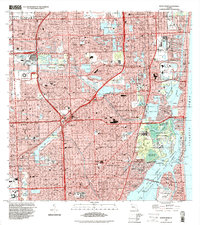
1994 Map of North Miami
USGS Topo · Published 2000About this map
Biscayne Bay and the surrounding coastline define this late-twentieth-century landscape, where intensive suburban development meets the Atlantic shore. The map illustrates a densely populated corridor characterized by a complex network of waterways, including the Intracostal Waterway, Maule Lake, and Snake Creek. Large-scale entertainment and recreational hubs are central to the region's identity, featuring landmarks like the Joe Robbie Stadium, Calder Race Course, and Gulfstream Park Racetrack.
Find a feature on this map
164 named features on this map. Tap any name to fly to it.
Don’t see what you’re looking for? This feature index may not catch every label — zoom into the map to look around manually.
Map Details
Editions of this 1994 North Miami Map
This is the sole edition of this map. No revisions or reprints were ever made.
Other maps of this area

1947 · North Miami
USGS Topo · 1:24,000

1949 · Opalocka
USGS Topo · 1:24,000

1949 · Port Everglades
USGS Topo · 1:24,000

1949 · Fort Lauderdale South
USGS Topo · 1:24,000

1950 · Hialeah
USGS Topo · 1:24,000

1950 · Miami
USGS Topo · 1:24,000

1950 · North Miami
USGS Topo · 1:24,000

1956 · Miami
USGS Topo · 1:250,000

1956 · West Palm Beach
USGS Topo · 1:250,000

1957 · West Palm Beach
USGS Topo · 1:250,000