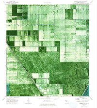
1974 Map of North Of Deem City
USGS Topo · Published 1993About this map
The Browns Farm Wildlife Management Area dominates the southeastern portion of this 1974 orthophotomap, revealing a landscape defined by the geometric intersection of agricultural drainage and conservation. Large-scale rectangular fields in the north contrast sharply with the more fluid, saturated terrain of the Everglades Wildlife Management Area Conservation Area No 3a to the south. Critical water management infrastructure is visible along the diagonal corridor of Levee 14, where several Pumps and a single Pump station facilitate the movement of water across the Palm Beach County wetlands. This survey provides a clear view of the mid-1970s balance between the expansion of industrial farming and the preservation of the Florida Everglades, showing exactly how human engineering reshaped the natural hydrology of the region.
Find a feature on this map
7 named features on this map. Tap any name to fly to it.
Don’t see what you’re looking for? This feature index may not catch every label — zoom into the map to look around manually.
Map Details
Editions of this 1974 North Of Deem City Map
2 editions found
Other maps of this area

1956 · West Palm Beach
USGS Topo · 1:250,000

1957 · West Palm Beach
USGS Topo · 1:250,000

1958 · West Palm Beach
USGS Topo · 1:250,000

1970 · Okeelanta
USGS Topo · 1:24,000

1970 · Loxahatchee SW
USGS Topo · 1:24,000

1970 · Shawano
USGS Topo · 1:24,000

1973 · Fort Lauderdale 2 SW
USGS Topo · 1:24,000

1974 · Everglades 1 SW
USGS Topo · 1:24,000

1974 · Everglades 1 NW
USGS Topo · 1:24,000

1974 · Everglades 1 SE
USGS Topo · 1:24,000