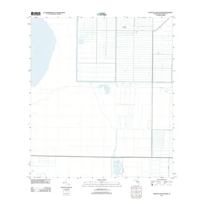
2012 Map of North of Gum Slough
USGS Topo · Published 2012About this map
Blue Cypress Lake dominates the northwestern corner of this Florida landscape, where the marshy edges of the St. Johns River headwaters meet an organized grid of drainage and agriculture. The terrain transition is sharp, moving from the open water and natural wetlands of the lake into a strictly partitioned network of canals and straight-line roads such as 79th St and 154th Ave. This layout reflects the intensive land management and citrus-focused history of the Fellsmere area. Near the northern boundary, the Fellsmere Airport sits among the citrus groves, while Corrigan Rd tracks south through the heavy irrigation infrastructure that defines the region’s agricultural economy in the early 21st century.
Find a feature on this map
5 named features on this map. Tap any name to fly to it.
Don’t see what you’re looking for? This feature index may not catch every label — zoom into the map to look around manually.
Map Details
Editions of this 2012 North of Gum Slough Map
This is the sole edition of this map. No revisions or reprints were ever made.
Other maps of this area

1949 · Fellsmere
USGS Topo · 1:24,000

1951 · Fellsmere
USGS Topo · 1:24,000

1953 · Fellsmere SW
USGS Topo · 1:24,000

1953 · Fort Drum
USGS Topo · 1:24,000

1953 · Fellsmere 4 SE
USGS Topo · 1:24,000

1953 · Fort Drum NE
USGS Topo · 1:24,000

1953 · Fellsmere 4 SW
USGS Topo · 1:24,000

1953 · Kenansville SE
USGS Topo · 1:24,000

1953 · Fellsmere 4 NW
USGS Topo · 1:24,000
1953 · Fellsmere 4 NE
USGS Topo · 1:24,000